What is Hydrology ?
Hydrology is the scientific study of the movement, distribution, and quality of water on Earth and other planets, including the hydro-logic cycle, water resources and environmental watershed sustainability. A practitioner of hydrology is a hydrologist, working within the fields of earth or environmental science,physical geography, geology or civil and environmental engineering.
Hydrology subdivides into surface water hydrology, groundwater hydrology (hydro-geology), and marine hydrology. Domains of hydrology include hydro-meteorology, surface hydrology, hydro-geology, drainage-basin management and water quality, where water plays the central role.
Description of the Hydrologic Cycle

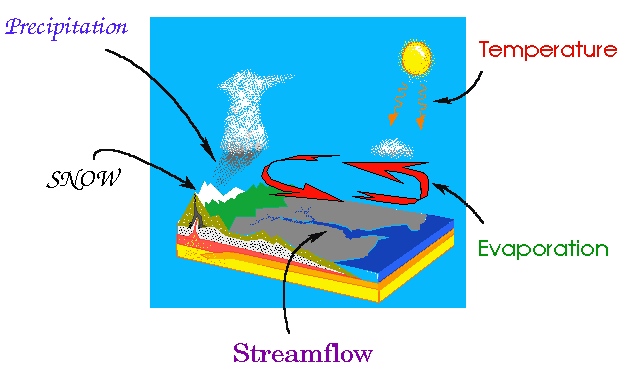
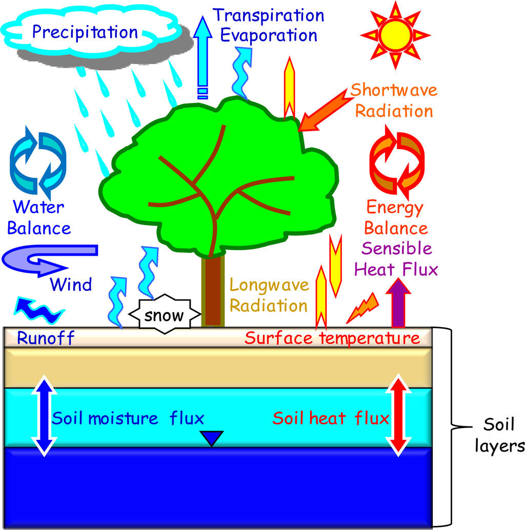
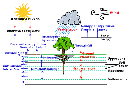
A fundamental characteristic of the hydrologic cycle is that it has no beginning an it has no end. It can be studied by starting at any of the following processes: evaporation, condensation, precipitation, interception, infiltration, percolation, transpiration, runoff, and storage.
Evaporation Process
 Evaporation :- Evaporation occurs when the physical state of water is changed from a liquid state to a gaseous state.Evaporation can occur on raindrops, and on free water surfaces such as seas and lakes. It can even occur from water settled on vegetation, soil, rocks and snow. There is also evaporation caused by human activities.
Condensation :- Condensation is the process by which water vapor changes it's physical state from a vapor, most commonly, to a liquid. Water vapor condenses onto small airborne particles to form dew, fog, or clouds.
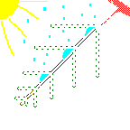
 Precipitation :- Precipitation is the process that occurs when any and all forms of water particles fall from the atmosphere and reach the ground. There are two sub-processes that cause clouds to release precipitation, the coalescence process and the ice-crystal process. As water drops reach a critical size, the drop is exposed to gravity and frictional drag.7th Grade Science-Groundwater & Surface Water
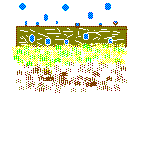 Infiltration :- Infiltration is the physical process involving movement of water through the boundary area where the atmosphere interfaces with the soil. The surface phenomenon is governed by soil surface conditions. Water transfer is related to the porosity of the soil and the permeability of the soil profile.
 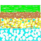 Percolation :-Percolation is the movement of water though the soil, and it's layers, by gravity and capillary forces. The prime moving force of groundwater is gravity. Water that is in the zone of aeration where air exists is called vadose water. Water that is in the zone of saturation is called groundwater. For all practical purposes, all groundwater originates as surface water. Once underground, the water is moved by gravity.
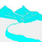 Runoff :-Runoff is flow from a drainage basin or watershed that appears in surface streams. It generally consists of the flow that is unaffected by artificial diversions, storages or other works that society might have on or in a stream channel. The flow is made up partly of precipitation that falls directly on the stream , surface runoff that flows over the land surface and through channels, subsurface runoff that infiltrates the surface soils and moves laterally towards the stream, and groundwater runoff from deep percolation through the soil horizons.
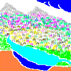 Storage :- There are three basic locations of water storage that occur in the planetary water cycle. Water is stored in the atmosphere; water is stored on the surface of the earth, and water stored in the ground. Water stored in the atmosphere can be moved relatively quickly from one part of the planet to another part of the planet. The type of storage that occurs on the land surface and under the ground largely depend on the geologic features related to the types of soil and the types of rocks present at the storage locations.
 |
| Water covers 70% of the Earth's surface. |

Water is one of our most important natural resources. Without it, there would be no life on earth. The supply of water available for our use is limited by nature. Although there is plenty of water on earth, it is not always in the right place, at the right time and of the right quality. Adding to the problem is the increasing evidence that chemical wastes improperly discarded yesterday are showing up in our water supplies today. Hydrology has evolved as a science in response to the need to understand the complex water systems of the Earth and help solve water problems. Hydrologists play a vital role in finding solutions to water problems, and interesting and challenging careers are available to those who choose to study hydrology.
Water and People
Estimates of water use in the United States indicate that about 355 billion gallons per day (one thousand million gallons per day, abbreviated Bgal/d) were withdrawn for all uses during 2010. This total has declined about 17 percent since 1980. Fresh groundwater withdrawals (76.0 Bgal/d) during 2010 were 8 percent less than during 1980. Fresh surface-water withdrawals for 2010 were 230 Bgal/d, 18 percent less than in 1980.
What Hydrologists Do?
Hydrologists apply scientific knowledge and mathematical principles to solve water-related problems in society: problems of quantity, quality and availability. They may be concerned with finding water supplies for cities or irrigated farms, or controlling river flooding or soil erosion. Or, they may work in environmental protection: preventing or cleaning up pollution or locating sites for safe disposal of hazardous wastes.
The areas of research within hydrology concern the movement of water between its various states, or within a given state, or simply quantifying the amounts in these states in a given region. Parts of hydrology concern developing methods for directly measuring these flows or amounts of water, while others concern modelling these processes either for scientific knowledge or for making prediction in practical applications.
Branches
- Chemical hydrology is the study of the chemical characteristics of water.
- Ecohydrology is the study of interactions between organisms and the hydrologic cycle.
- Hydrogeology is the study of the presence and movement of groundwater.
- Hydroinformatics is the adaptation of information technology to hydrology and water resources applications.
- Hydrometeorology is the study of the transfer of water and energy between land and water body surfaces and the lower atmosphere.
- Isotope hydrology is the study of the isotopic signatures of water.
- Surface hydrology is the study of hydrologic processes that operate at or near Earth's surface.
- Drainage basin management covers water-storage, in the form of reservoirs, and flood-protection.
- Water quality includes the chemistry of water in rivers and lakes, both of pollutants and natural solutes.
- Oceanography is the more general study of water in the oceans and estuaries.
- Meteorology is the more general study of the atmosphere and of weather, including precipitation as snow and rainfall.
- Limnology is the study of lakes. It covers the biological, chemical, physical, geological, and other attributes of all inland waters (running and standing waters, both fresh and saline, natural or man-made).
- Water resources are sources of water that are useful or potentially useful. Hydrology studies the availability of those resources, but usually not their uses.
Applications
- Determining the water balance of a region.
- Determining the agricultural water balance.
- Designing riparian restoration projects.
- Mitigating and predicting flood, landslide and drought risk.
- Real-time flood forecasting and flood warning.
- Designing irrigation schemes and managing agricultural productivity.
- Part of the hazard module in catastrophe modeling.
- Providing drinking water.
- Designing dams for water supply or hydroelectric power generation.
- Designing bridges.
- Designing sewers and urban drainage system.
- Analyzing the impacts of antecedent moisture on sanitary sewer systems.
- Predicting geomorphologic changes, such as erosion or sedimentation.
- Assessing the impacts of natural and anthropogenic environmental change on water resources.
- Assessing contaminant transport risk and establishing environmental policy guidelines.
Hydrilogy (Ground Water &Surface Water)
Groundwater
 Ground water is water beneath Earth's surface, often pumped for drinking water.Groundwater hydrology (hydro-geology) considers quantifying groundwater flow and solute transport.Problems in describing the saturated zone include the characterization of aquifers in terms of flow direction, groundwater pressure and, by inference, groundwater depth (see: aquifer test). Measurements here can be made using a piezometer. Aquifers are also described in terms of hydraulic conductivity, storativity and transmisivity. There are a number of geophysical methods for characterizing aquifers. There are also problems in characterizing the vadose zone (unsaturated zone).
Groundwater, pumped from beneath the earth's surface, is often cheaper, more convenient and less vulnerable to pollution than surface water. Therefore, it is commonly used for public water supplies. Groundwater provides the largest source of usable water storage in the United States. Underground reservoirs contain far more water than the capacity of all surface reservoirs and lakes, including the Great Lakes. In some areas, ground water may be the only option. Some municipalities survive solely on groundwater.[ Ground Water ]
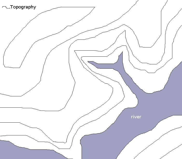
Surface Water
 Hydrology considers quantifying surface water flow and solute transport, although the treatment of flows in large rivers is sometimes considered as a distinct topic of hydraulics or hydrodynamics. Surface water flow can include flow both in recognizable river channels and otherwise. Methods for measuring flow once water has reached a river include the stream gauge, and tracer techniques. Other topics include chemical transport as part of surface water, sediment transport and erosion.
 One of the important areas of hydrology is the interchange between rivers and aquifers. Groundwater/surface water interactions in streams and aquifers can be complex and the direction of net water flux (into surface water or into the aquifer) may vary spatially along a stream channel and over time at any particular location, depending on the relationship between stream stage and groundwater levels.
Infiltration :- Infiltration is the process by which water enters the soil. Some of the water is absorbed, and the rest percolates down to the water table.
Surface water flow

Hydrology considers quantifying surface water flow and solute transport, although the treatment of flows in large rivers is sometimes considered as a distinct topic of hydraulics or hydrodynamics. Surface water flow can include flow both in recognizable river channels and otherwise. Methods for measuring flow once water has reached a river include the stream gauge, and tracer techniques. Other topics include chemical transport as part of surface water, sediment transport and erosion.
One of the important areas of hydrology is the interchange between rivers and aquifers. Groundwater/surface water interactions in streams and aquifers can be complex and the direction of net water flux (into surface water or into the aquifer) may vary spatially along a stream channel and over time at any particular location, depending on the relationship between stream stage and groundwater levels.
Soil moisture
Soil moisture can be measured in various ways; by capacitance probe, time domain reflectometer or Tensiometer. Other methods include solute sampling and geophysical methods.
Water quality
In hydrology, studies of water quality concern organic and inorganic compounds, and both dissolved and sediment material. In addition, water quality is affected by the interaction of dissolved oxygen with organic material and various chemical transformations that may take place. Measurements of water quality may involve either in-situ methods, in which analyses take place on-site, often automatically, and laboratory-based analyses and may include microbiological analysis.
Prediction
Observations of hydrologic processes are used to make predictions of the future behaviour of hydrologic systems (water flow, water quality). One of the major current concerns in hydrologic research is "Prediction in Ungauged Basins" (PUB), i.e. in basins where no or only very few data exist.
Statistical hydrology
 By analyzing the statistical properties of hydrologic records, such as rainfall or river flow, hydrologists can estimate future hydrologic phenomena. When making assessments of how often relatively rare events will occur, analyses are made in terms of the return period of such events. Other quantities of interest include the average flow in a river, in a year or by season.
These estimates are important for engineers and economists so that proper risk analysis can be performed to influence investment decisions in future infrastructure and to determine the yield reliability characteristics of water supply systems. Statistical information is utilized to formulate operating rules for large dams forming part of systems which include agricultural, industrial and residential demands.
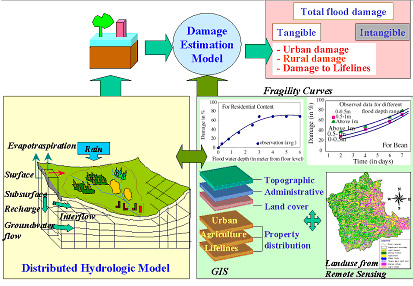
Modeling
Hydrological models are simplified, conceptual representations of a part of the hydrologic cycle. They are primarily used for hydrological prediction and for understanding hydrological processes, within the general field of scientific modeling. Two major types of hydrological models can be distinguished:
- Models based on data :- These models are black box systems, using mathematical and statistical concepts to link a certain input (for instance rainfall) to the model output (for instance runoff). Commonly used techniques are regression, transfer functions, and system identification.
- Models based on process descriptions :-These models try to represent the physical processes observed in the real world. Typically, such models contain representations ofsurface runoff, subsurface flow, evapotranspiration, and channel flow, but they can be far more complicated. These models are known as deterministic hydrology models. Deterministic hydrology models can be subdivided into single-event models and continuous simulation models.

Transport
Integrating measurement and modelling
- Budget analyses
- Parameter estimation
- Scaling in time and space
- Data assimilation
- Quality control of data – see for example Double mass analysis
Applications of Remote Sensing and GIS in Hydrology
Remote Sensing and GIS technologies are well-established tools and are routinely used in applied hydrology, forestry, land use dynamics analyses, etc. Abilities of remote sensing technology in hydrology are to measure spatial, spectral, and temporal information and provide data on the state of the earth's surface. It provides observation of changes in hydrological states, which vary over both time and space that can be used to monitor hydrological conditions and changes. Sensors used for hydrological applications cover a broad range of electromagnetic spectrum. Both active sensors that send a pulse and measure the return pulse (like radar, microwave etc.) and passive sensors that measure emissions or reflectance from natural sources (like Sun, thermal energy of the body) are used. Sensors can provide data on reflective, thermal and dielectric properties of earth's surface.
Remote sensing techniques indirectly measure hydrological variables, so the electromagnetic variables measured by remote sensing have to be related to hydrological variables empirically or with transfer functions.
Remote sensing applications in hydrology that are being used today are mainly in:
- · Precipitation estimation
- · Runoff computations
- · Snow hydrology applications
- · Evapotranspiration over land surface
- · Evaluation of soil moisture content
- · Water quality modelling
- · Groundwater identification and estimation
- · Hydrological modelling
GIS can play fundamental role in the application of spatially distributed data to hydrological models. In conventional applications, results either from remote sensing or from GIS analyses serve as input into hydrological models. Land use and snow cover are the most commonly used input variables for hydrological models. The integration of GIS, database management systems and hydrological models speed up the use of remote sensed data in hydrological applications.


No comments:
Post a Comment